 Archeoplus
Chavannes-le-Chêne (VD)
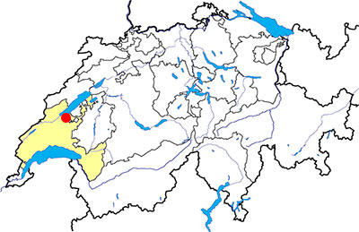
Canton: Vaud
Swiss topographic coordinates: 549'530, 180'869
Google Earth file: Chavannes-ch-en.kmz
OpenStreetMap: https://www.openstreetmap.org/relation/1684891
Documentation
Bibliography
- Anderson T., Duvauchelle A., Agustoni C., “Carrier et forgeron gallo-romains à Chables” dans Cahiers d’archéologie fribourgeoise, n° 3, 2001, pp. 2-13
- Le Bec Erwan, Le passé pas à pas (see Bibliography), volume 2, pp. 58-63
- Weidmann D., “Chavannes-le-Chêne VD, carrière romaine” dans Annuaire de la Société suisse de préhistoire et d’archéologie (ASSPA), 2002, p. 313
Links
- Chavannes-le-Chêne: Histoire et découvertes : https://chavannes-le-chene.ch/tourisme/histoire-et-decouvertes
- Sites visitables - Etat de Vaud : https://www.vd.ch/territoire-et-construction/archeologie/sites-archeologiques-visibles-et-invisibles/sites-visitables
Others visible sites in the area
- Gressy-Sermuz (VD): Celtic oppidum
- Molondin (VD): Medieval village of La Tour Saint-Martin
- Ursins (VD): Gallo-Roman temple
- Yverdon-les-Bains (VD): Menhirs, Roman castrum, medieval city (castle, museum)
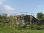
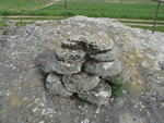
The Roman quarry
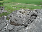
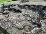
In the plain on the north of Chavannes-le-Chêne, a Roman millstone quarry is visible on a small bound. Firstly dug up and developped for the visits, the quarry has been cleaned and restudied in 2001.
This quarry was exploited for the millstones in sandstone known as “de la Molière”. According to the calculations made in 2001, there has been approximately 800 rough shapes with a diameter of 40 centimetres that have been cut in this place. Another Roman quarry has been dug up at Chables (canton of Fribourg) where the rough shapes were cut with the same quality and the same technics.
Nowadays, it is possible to see a part of the quarry and some rough shapes. Explicative panels have been installed to explain the history and the geology of the place.
Swiss topographic coordinates: 549'894, 181'952
OpenStreetMap: https://www.openstreetmap.org/node/3705495399