 Archeoplus
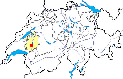
Riaz (FR)
Documentation
Bibliography
- Cardinaux Stéphane, Géométries sacrées, volume 2, Editions Trajectoire, 2006, pp. 92-93
- Fuchs Michel, "Ursins VD et Riaz FR: mêmes combats pour Mars Caturix?", in Archéologie Suisse 20, 1997, p. 149-158
- Spycher Hans Peter, Zaugg Marc, Des Romains aux Carolingiens: le haut Moyen-Age, L'Histoire suisse en image (volume 4), Lausanne, 1988, pp. 46-57
- Vauthey Pierre-Alain, Riaz/Tronche-Bélon, le sanctuaire gallo-romain, Archéologie fribourgeoise 2, Fribourg, 1985, 117 p.
Links
- MEMO - Le site de l'Histoire: http://www.memo.fr/LieuAVisiter.asp?ID=VIS_SUI_FRI_044
Others visibles sites in the area
- Pont-en-Ogoz (FR): Medieval town (castle, chapel)
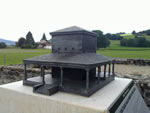
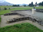
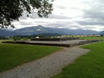
The Gallo-Roman temple
During the Roman period, the temple wasn’t isolated in the country, but was a part of a town which had, apart the houses, a public bath.
A first wooden temple has been built at the beginning of the first century AD, then a new building built in masonry replaced the wooden temple. Several pieces of inscriptions allow to attribute the temple to the god Mars Caturix. The sanctuary is destroyed during the 3rd century AD with the barbarian invasions, then the site becomes a cemetery during the 6th and 7th century.
The temple has been excavated between 1852 and 1853, and then between 1974 and 1976. As it was on the route of the future motorway, the walls have been displaced a few metres to the west. Nowadays, it is possible to look at the remains of the cella (room of worship), of the walls of the portico around the cella, and of two walls of the stairs for the access of the temple. There are also several information panels and a scale model of the temple.
Swiss topographic coordinates: 571'294, 166'458