 Archeoplus
Pont-en-Ogoz (FR)
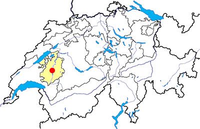
Canton: Fribourg
Swiss topographic coordinates: 573'429, 172'216
Google Earth file: Pont-Ogoz-en.kmz
Documentation
Bibliography
- Pont-en-Ogoz ; édité par le service archéologique de l'Etat de Fribourg ; tiré à part : Cahiers d'archéologie fribourgeoise, 6, 2004, pp. 14-64
- Ansermet Stephan, Guide des lieux mystérieux de Suisse romande (see Bibliography), pp. 60-69
- Gasser Bernard, Ogoz, De la cité à l'île, Autoédition - Association Île d'Ogoz, 2014, 128 p.
- Zwahlen Frank R (dir.), Châteaux forts de la Suisse, Zurich, 9, 1983, pp. 86-87
Links
- Association Île d'Ogoz: http://www.ogoz.ch
- Commune de Pont-en-Ogoz: http://www.pont-en-ogoz.ch/fr/
- Ogoz Island (Wikipedia): http://en.wikipedia.org/wiki/%C3%8Ele_d%27Ogoz
Others visibles sites in the area
- Arconciel (FR): Prehistoric settlement, medieval castle
- Riaz (FR): Gallo-Roman temple
- Rossens (FR): Illens medieval castle
Ogoz Island
Archaeological excavations conducted in 1947-1948 and in 2002-2003 led to certify human presence on the site since prehistoric times. Several Mesolithic stone artefacts were found, and some stone objects and ceramics from the Neolithic period. Ceramic materials and stone dating from the Middle Bronze Age and also attest to the final human occupation of the site during this period. The testimony of the Iron Age and Roman times are few. The site occupation in the Middle Ages is attested by historical sources from the thirteenth century to the seventeenth century. Then the town and castle were abandoned and the buildings are stone quarries.
Access
During the period of low-water mark, it is possible to go to the island by foot. During the rest of the year, the island can be reached by boat, and the sundays afternoon, since May to October, the Association Île d'Ogoz organizes excursions Ogoz Harbour, at le Bry.
Swiss topographic coordinates: 574'117, 171'953

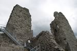
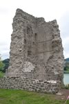
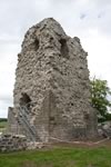
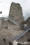
The castle
Currently, the most striking elements of the castle are the two towers, visible from afar. The excavations in 1947-1948 have been able to demonstrate the existence of a third tower, whose foundations, make big balls till and different from the other two towers, built of sandstone, suggest a building during the twelfth century. The central tower, too small to be habitable, was probably built in the mid-thirteenth century and was linked to several buildings. The Southern tower, built between the late thirteenth and the first half of the fourteenth century, had larger dimensions but its condition does not allow to attest if it could be habitable. A building was attached to the east.
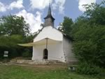
The chapel
The chapel is the only non-ruined buildings of the ancient village. It is mentioned in the sources for the first time in 1226. Rectangular in plan, the current building is the result of several transformations. The construction was carried out mainly between the thirteenth and fifteenth centuries, with some modifications, including the development of the altarpiece was restored in 1999, between the late sixteenth and the first half of the seventeenth century.