 Archeoplus
Orbe (VD)
Orbe is a small city crossed by a river which has the same name. The oldest remains left by humans are dated of the Neolithic Age. A Celtic house has been dig up at the so-called place Bosceaz, and several Roman settlements are knwon in the area, such as the one at Montchoisi, knwon by the prospections, and mainly the one at Bosceaz, which was the biggest Roman farm knwon at the North of the Alps.
If the history of Orbe during the High Middle Ages is knwon with several texts, its archaeological past during that period has let few remains. The city grows up arround the castle, then it is protected y a city wall during the 13th century. At the 15th, the city is taken by the Confederates and the the castle is burn. At the 18th, a tower of the city wall is transformed into a hospital.
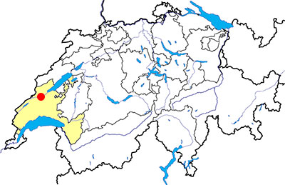
Canton: Vaud
Swiss topographic coordinates: 530'696, 175'174
Google Earth files:
OpenStreetMap: https://www.openstreetmap.org/#map=15/46.7271/6.5395
Old names:
- Urba
- Vicus Urbensis
Documentation
Bibliography
- Auberson Laurent, Orbe. Histoire et architecture : De la fin de l'Antiquité au XXe siècle, Neuchâtel, Livreo/Alphil, coll. « Itineo. Histoire et patrimoine », 2022, 275 p.
- Auberson Laurent, Dubois Yves, Le Pont du Moulinet; De 1424 à 2024, 600 années d'histoire, Orbe, 2024, 72 p.
- Barbey Frédéric, Naef Albert, Orbe, Notice historique illustrée, Orbe, Albert Velay, 1920, 93 p.
- Barbey M., Decollogny L., Poget S.-W., Urba, Mosaïques et vestiges romains de Boscéaz, près Orbe, Orbe, Librairie Velay, 1929, 63 p., 13 planches (document available online at: E-Periodica)
- Berger Ric, Le Nord vaudois (see Bibliography), pp. 101-128
- Delbarre-Bärtschi Sophie, Les mosaïques romaines de Suisse (see Bibliography), pp. 261-267, pl. 44-48
- Dubois Yves, Urba II., Ornementation et discours architectural de la villa romaine d'Orbe-Boscéaz, Lausanne, Cahiers d'Archéologie Romande 163-165, 2016
- Flutsch L. et al., La villa gallo-romaine d'Orbe-Boscéaz et ses mosaïques, Orbe, Guides archéologiques de la Suisse 5, 1997, 58 p.
- Gilliard Frédéric, L'église d'Orbe, étude historique et archéologique, Orbe, Librairie Jaques, 1934, 46 p.
- von GonzenBach Victorine, Les mosaïques romaines d'Orbe, Orbe, Guides archéologiques de la Suisse 5, 1974, 41 p.
- Le Bec Erwan, Le passé pas à pas (see Bibliography), volume 3, pp. 100-105
- Liboutet Marion, "Orbe au Moyen-Âge. Du nouveau sur les fortifications urbigènes" in Archéologie vaudoise. Chroniques 2013, 2014, pp. 62-73
- Luginbhül Thierry et al., Vie de palais et travail d'esclaves, La villa romaine d'Orbe-Boscéaz, Lausanne, 2001, 120 p. (Document available on this page)
- May Castella Catherine, "Conservation et mise en valeur de la villa gallo-romaine d'Orbe; Patience et longueur de temps" in Archéologie vaudoise. Chroniques 2015, 2016, pp. 26-31
- Paunier Daniel, Luginbhül Thierry et alii, Urba I. La villa romaine d'Orbe-Boscéaz, Genèse et devenir d’un grand domaine rural, Lausanne, Cahiers d'Archéologie Romande 161-162, 2016
- de Reamy Daniel, "La tour ronde du château d'Orbe: une typologie des "donjons circulaires" revisités", extrait de Des pierres et des hommes, Lausanne, Bibliothèque historique vaudoise, 1995, pp. 175-190
- 100% Archéologie suisse (see Bibliography), p. 94
- Vuitel Paul-André, 36 curiosités remarquables de la plaine de l'Orbe (voir Bibliography), p. 4-19
- Weidmann Denis, Pignat Gervaise, Wagner Carine, Vu du ciel (see Bibliography), pp. 30-31, 60-61
Links
- Fundation and Association Pro Urba: https://www.pro-urba.ch/
- Opening hours of the Roman mosaics:http://www.roman-mosaics.ch
- Commune of Orbe: Visiter: https://www.orbe.ch/ma-ville/decouvrir-orbe/visiter.html
- Swissinfo.ch: Switzerland’s hidden treasure trove of Roman mosaics: https://www.swissinfo.ch/eng/roman-ruins_switzerland-s-hidden-treasure-trove-of-roman-mosaics-/44330286
- Sites archéologiques visibles et invisibles: La villa et les mosaïques romaines d'Orbe-Boscéaz: https://www.vd.ch/themes/territoire-et-construction/archeologie/sites-archeologiques-visibles-et-invisibles#c2028809
- Patrimoine au fil de l'eau: http://www.eau21.ch
Others visible sites in the area
- Ballaigues (VD): Road with ruts
- Montcherand (VD): Medieval church
- Romainmôtier (VD): Romanesque abbey church, low furnaces
- Vallorbe (VD): Museum
- Vuiteboeuf (VD): Castle, medieval tower
- Yverdon-les-Bains (VD): Menhirs, Roman castrum, medieval city (castle, museum)
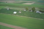
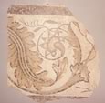
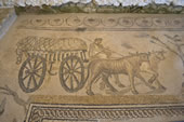
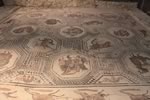
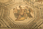
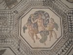
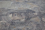
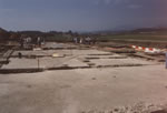
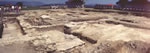
The Roman villa
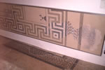
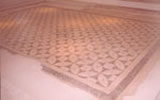
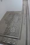
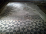
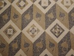
To the north of the present town of Orbe, at the place knwon as Bosceaz, there was a rich Roman villa (farm) built between the second and the third century AD. The living quarters of the owners were organized around two big squarred court yards. Some rooms were decorated with mosaics (10 are known in the living quaters) and murals. Private bath and a mithraeum (temple consecrated to the oriental god Mithra) were also part of the farm.
Between 1986 and 2004, the place was the teaching-site for the students in archaeology of the University of Lausanne, which organized excavations there. During these excavations, here are the most spectacular discoveries: in 1993, the ninth mosaic; in 1996, the mithraeum; in 1998, the baths.
Nowadays, only 8 mosaics, in small houses, are open for public visits. The modern reception pavillon, with a permanent exhibition, has been opened in 2010. The restoration of the last mosaic is finished since 2011, and a new temporary protection pavillon has been built in 2015, but it is open for the public only when there are open days events or colloquiums. Its permanent aperture for the public as well as a more complete presentation of the other structures will be possible only after a complete developement project of the site
Via Storia, an free application available on thevApp Store and Google Play, gives an interactive visit of the site. It is also possible to rent on site a tablet with the application.
Since 2022, thanks to municipal and cantonal subsidies, the site is open: Saturdays, Sundays and public holidays in May, June and October; Wednesdays to Sundays in July, August and September; by prior arrangement on other days.
Swiss topographic coordinates: 531'086, 177'832
OpenStreetMap: https://www.openstreetmap.org/way/81645578
The medieval city
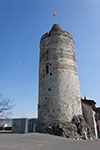
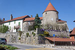
The castle
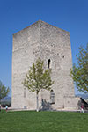
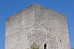
Nowadays, the castle esplanade is a public square dominated by two old towers. This esplanande exists since 1835, when several towers of the castle have been destroyed and a terrace has been built ont the north. In the centre of the east side of the esplanade, the squared tower has no longer its coping stone and its floors.
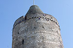
On the east, the round tower was the castle keep. A piece of beam allowed to date the construction at 1232-1233. The top of the tower is transformed in at the beginning of the 14th century. In 1475, the timber frame is destroyed during the siege and the fire of the castle by the Confederates. During a long period, up to 1870, the top of the tower becomes the support of a stork nest.
If the original door of the tower was 10 metres above the ground, it is possible to enter through a modern door bored at the ground level, and to visit the different floors. From the top, there is a beautifull view of the city and the plain.
Swiss topographic coordinates: 530'759, 175'325
OpenStreetMap: https://www.openstreetmap.org/node/495167320
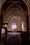
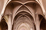
The church
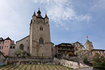
Located at the south of the castle, the parish church has a tumultous history. The first building built there was a chapel dedicated to Notre Dame during the 12th century, but the archaeological excavations didn't allowed to confirm its existence. After a fire, the church is rebuilt at the beginning of the 15th century with a nave and two side aisles, a chapel on the north-east, and the reuse of a floor of city wall tower as chancel.
In 1475, the fire which damage the castle destroyed also the church, and it remained only the outside walls and the chancel tower. The building is rebuilt with masonry vaults and pillars, and three chapelas are added. In the 17th century, a new fire damage the church, and the side chapels are transformed into side aisles during the renovation.
Swiss topographic coordinates: 530'746, 175'225
OpenStreetMap: https://www.openstreetmap.org/way/231422863
The city wall
It remains several elements of the city wall built during the 13th century. The bell tower of the church was a part of it. Near the old school, the Bernard tower, a round-shape tower, owns a timber frame dated from the 15th century.
If both towers aforementioned have always been visible, a third tower was studied beween 2012 and 2013. Built in the south of the city, the abbey tower played a defensive role between the 13th and the 15th century. In the 15th centutry, transformations are done to in order to be the tower fit for habitation, then, between the the 15th and the 19th century, annexes are built around the building. In the 18th century, the tower and its annexes became the first orthopaedic hospital in the world. Since 2012, the annexes are demolished and the medieval tower is classified as an historic monument. This tower, nowadays a housing, is a private property and cannot be visited.
Swiss topographic coordinates:
- Bernard tower: 530'654, 175'010
- Abbey tower: 530'718, 174'860
The museum
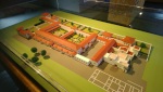
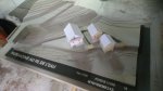
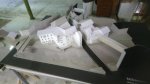
Located in the city centre, the museum shows various objects dating from the Neolithic Age up to nowadays (scale model of the Roman villa, paintings,...) about the local history. The museum is currently closed due to conversion work. The museum's cellar, which is used for lectures by the Association of Friends of Pro Urba and for coffee roasting sessions, can be hired out for private functions.
Swiss topographic coordinates: 530'734, 175'084
OpenStreetMap: https://www.openstreetmap.org/node/495167435
Moulins Rod
On the left bank of the Orbe, at the end of rue du Moulinet, a mill (in French: moulin) was built in the 15th century. This mill, bought by Jules Rod in 1871, was partially rebuilt in 1880. During the 20th century, it was extended by extensions on the right bank of the river. Flour production fell at the end of the 20th century and stopped completely in 1997.
Nowadays, the buildings on the left bank house a museum, Patrimoine au fil de l'eau, dedicated to the industrial history of the region and various cultural activities are offered. You can still see part of the walls of the medieval mill. Although this part of the museum is listed, it has been closed to the public since the end of 2020. The buildings on the south shore, which are not classified, will be demolished.
Swiss topographic coordinates: 530'746, 174'853
OpenStreetMap: https://www.openstreetmap.org/node/4555657956
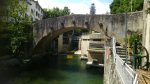
Moulinet Bridge
Located next to the Moulins Rod, the Moulinet bridge is currently the oldest in Switzerland that is open to traffic. Its construction began in 1421 on the initiative of a hermit who lived nearby, and was completed in 1424. This single-arch bridge has retained its original appearance, except for the addition of metal reinforcements installed around 1880.
Swiss topographic coordinates: 530'722, 174'822
OpenStreetMap: https://www.openstreetmap.org/way/41504889