 Archeoplus
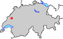
Gorgier (NE)
Situated in a region rich in megalithic monuments, the village of Gorgier possesses several menhirs on its territory, mainly in Devens wood. Another menhir, that of Châtillon in the neighborhood of Gorgier castle, is quoted as destroyed in the book of V.-H. Bourgeois.
Documentation
Bibliography
- Bourgeois Victor.-H., Les Monuments Mégalithiques (see Bibliography), p. 35
- Collectif, Le livre à remonter le temps (see Bibliography), p. 89
- D'un mégalithe à l'autre (see Bibliography), pp. 54-55
- Egloff Michel, Histoire du Pays de Neuchâtel (see Bibliography), p. 69, p.144
Links
- Note sur les menhirs de la région de Gorgier: http://www.gorgier.ch/d2wfiles/document/122/5021/0/Menhirs.pdf
- Les Devens menhir de Gorgier: http://www.megalithic.co.uk/article.php?sid=33661
- SSID Steindenkenmäler-Inventar Canton de Neuchâtel: http://www.ssdi.ch/Inventar/NE.htm
Others visible sites in the area
- Bevaix (NE): Menhir
- Concise (VD): Roman quarry, medieval Carthusian monastery
- Corcelles-Concise (VD): Menhirs
- Fresens (NE): Dolmen
- Saint-Aubin-Sauges (NE): Menhirs
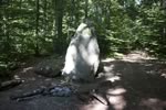
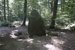
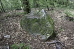
The monuments of Les Devens
The "Grand menhir" (big menhir) of Devens wood is situated in a small clearing, east of the nearby menhirs of Saint-Aubin-Sauges. Constituted by a granite block, it measures approximately 3 meters in height for 1,4 meters in width. The pit dug around the menhir is the result of the excavations undertaken in the 1860s by Doctor Gustave Clément, amateur of antique established at Saint-Aubin. A paving stone of red granite as well as fragments of ceramic and charcoals were discovered during these excavations.
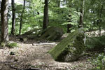
Not far from the big menhir, we can see in the forest the three "Pierres du Guénégou" (Guénégou stones), partially slept menhirs which are at the foot of a hillock, maybe artificial.
Swiss topographic coordinates:
- Grand menhir: 548'905, 195'420
- Pierres du Guénégou: 549'003, 195'488