 Archeoplus
Corcelles-près-Concise (VD)
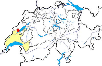
Canton: Vaud
Swiss topographic coordinates: 544'262, 188'712
Google Earth file:
OpenStreetMap: https://www.openstreetmap.org/#map=16/46.8474/6.7063
Documentation
Bibliography
- Bourgeois Victor, Au pied du Jura (see Bibliography), pp. 218-222
- Burri-Wyser Elena (dir.), Destins des mégalithes vaudois (see Bibliography)
- Burri-Wyser Elena (dir.), « Stèles ornées, menhirs sculptés et pierres à cupules ; un regard sur les mégalithes vaudois », Archéologie vaudoise, Chroniques 2015, 2016, pp. 44-57
- Cardinaux Stéphane, Géométries sacrées, Editions Trajectoire, 2004, pp. 128-129
- D'un mégalithe à l'autre (see Bibliography), pp. 44-49
- Guide des hauts lieux vibratoires de Suisse romande (see Bibliography), pp. 114-117
- Le livre à remonter le temps (see Bibliography), p. 54
Links
- Grandson - Yverdon-les-Bains Region Jura Lac (Switzerland) - The menhirs of the Grandson region: http://www.grandson-tourisme.ch/en/page.cfm/Culture_Patrimoine/Sites_historiques_religieux/menhirs_region_grandson
- Pierres Longues de Corcelles Standing Stones: The Megalithic Portal and Megalith Map: http://www.megalithic.co.uk/article.php?sid=6336165
Others visible sites in the area
- Concise (VD): Roman quarry, medieval Carthusian monastery
- Fresens (NE): Dolmen
- Onnens (VD): Dolmen
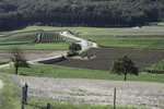
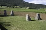
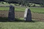
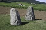
The four menhirs
Between a path and a field, fours menhirs are visible at the north of the village. Three of these menhirs are prehistoric, and the fourth one, at the north-west, was cut and set up in 1843 to replace a menhir removed during the 18th century.
These menhirs have been always visible, but it was only in 1994 that an excavation is done to understand the organisation of the megalithic monument. A medieval pit, near the southern menhirs contained a megalith cut in two parts, proves that there was at least 4 menhirs. The excavations allowed also to date the monument from the Neolithic Age.
Among the three prehistorical menhirs, there is the north-west one who has a leveled top and several cupules.
The site wasn't isolated as the human occupation has been attested near the neighbouring village of Onnens and also on the lakeside where another menhir (see below) and a lakeside village have been studied.
Swiss topographic coordinates: 543'829, 189'042
OpenStreetMap: https://www.openstreetmap.org/node/686847259
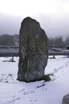
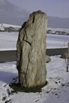
The menhir of La Vernette
On the south of the village, near the railway, a menhir seams to be lost in the country side. This menhir, unlike the others described above, is not on its original palce. Discovered in 1997 during the railwayworks, it was set up there in 2005, some 700 metres far from the discover place.
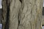
The menhir is made of gneiss, the top is cut into a point and the base has a rectangular shape. A line, engraved on the southern side of the menhir, can be interpreted as a belt, and the monument would be a statue-menhir. No object allows to date when it was set up or laid on its side, but the presence of statues-menhirs is attested since the Final Neolithic Age.
Swiss topographic coordinates: 544'343, 188'273
OpenStreetMap: https://www.openstreetmap.org/node/2451483830