 Archeoplus
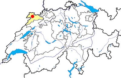
Courgenay (JU)
Documentation
Bibliography
- Guide archéologique du Jura et du Jura bernois (see Bibliography), pp. 53-54
- Le livre à remonter le temps (see Bibliography), p. 56
Links
- Web site of Courgenay: http://www.courgenay.ch/fr/tourisme/curiosites/
Others visible sites in the area
- Cornol (JU): Celtic oppidum
- Sainte-Ursanne (JU): Medieval collegiate church
- Vicques (JU): Gallo-Roman villa
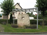
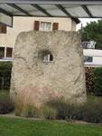
The “Pierre Percée” dolmen
In the village of Courgenay, it is possible to see the “Pierre Percée” (pierced stone), last visible remain of a dolmen, prehistoric funeral monument. This stone, 2.5 metres high and 2.3 metres wide, has a oval hole of 35 x 41 centimetres. No object has been found during the graves, but it was possible to date the monument, with the comparison with other same monuments, from the neolithic, at 3000 BC approximately.
Various beliefs have been attributed at the Pierre Percée. For example, at the beginning of the 18th century, it was considerated as a commemorative monument for the victory of the German Arioviste over the Gaulish people, or later, during the Revolution, as a monument for the victory of Julius Caesar over the Germans.
Swiss topographic coordinates: 575'850, 250'642